MADRID
The history of Europe has been long-shaped by wars. Indeed, the traumatic events of both the First and Second World Wars still play a part in the continent’s make up today.
But for some residents living between Spain and France, there’s a much older — and largely forgotten conflict — that still shapes their lives today.
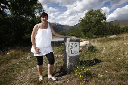
Take the 1,700 citizens who live in the village of Llivia. Officially, it’s part of Spain, and is administered by the regional government of Girona.
But since November 7, 1659, the little part of Spain has been completely surrounded by France. Llivia lies entirely inside France and is cut off from the rest of the Spanish nation by five kilometres of French territory.
The village sits 1,300 metres up in the Pyrenees Mountains, two hours’ drive mostly northwest of Barcelona. And while the road to the village belongs to France, a set of white boundary stones along with Spanish and Catalan flags, are the only indication you’re in a little part of Spain — a home away from the homeland.
For three decades, the Thirty Years War raged across Europe between the kingdoms of Spain and France, tied up the kingdom of Sweden and its occupation of present-day Poland, involved the English and the Dutch, Luxembourgers and the Austrians.
The entire war finally came to an end with the Treaty of the Pyrenees, signed on November 7, 1659 on Pheasant Island. That agreement largely settled the boundaries between France and Spain, and some 30-odd villages in the Querol Valley were ceded by King Philip IV of Spain to France.
Not the only anomaly
But Llivia was an anomaly then — and remains so today. It was classified as a ‘vila’ — a throwback to its Roman roots — rather than a village, and so was overlooked by the peacemakers. Ever since then, it’s been a little part of Spain squarely set inside France.
During the Spanish Civil War and the Second World War that followed, the Spanish residents of Llivia were largely isolated from any contact across the border. Now, with the open borders of the European Union, life is relative simply, unless you need to get new services from Spain extended into the village.
A water agreement for a new water source was signed in the early 1970s, but the residents waited for more than 40 years for the pipes to be hooked up. As it is now, a health service in the village services French citizens as well — thanks to the EU’s sharing of services.
But the status of Llivia isn’t the only anomaly thrown up by the architects of the Treaty of the Pyrenees.
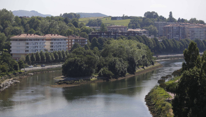
That island where the treaty between the Spanish and French realms remains an historical, political and geographical anomaly to the present day.
The island sits in the Bidasoa River separating northeast Spain and southwest France, where the French city of Hendaye sits opposite the Spanish town of Irun. It’s roughly 5,000 square metres in size.
A cow and three ducks
To celebrate the end to the Thirty Years’ War, both Philip IV and King Louis XIV of France agreed that ownership of the small island where the treaty was signed would be shared between the two realms.
From January to June each year, it belongs to Spain, and from July to December, is French territory.
Thankfully, the island is uninhabited, and access to it is strictly controlled.
“It requires little attentions,” said Commander Rafael Preito from the Spanish naval base in San Sebastian, who took charge of the territory up to June. It then moved to the administration of the French and a naval station in Bayonne.
“People are very respectful,” he said. “No one tries to trespass [on Pheasant Island] even though the tide is so low you can almost walk across to it. We typically enter every five days to carry out routine maintenance.”
And despite its name, there are no actual pheasants there either.
“At most, there was a cow and three ducks, probably rented by resident to take the role of pheasants for visitors,” French literary great Victor Hugo complained in 1843 after visiting the site.
There is, however, one positive side to the fact that it is looked after by both the Spanish and the French. When the treaty was signed, it measured just 80 metres by 5. Both nations shore up the island and work on the tidal flows, and it has actually grown now to its present 215 metres by 38. That’s international cooperation at work for you.