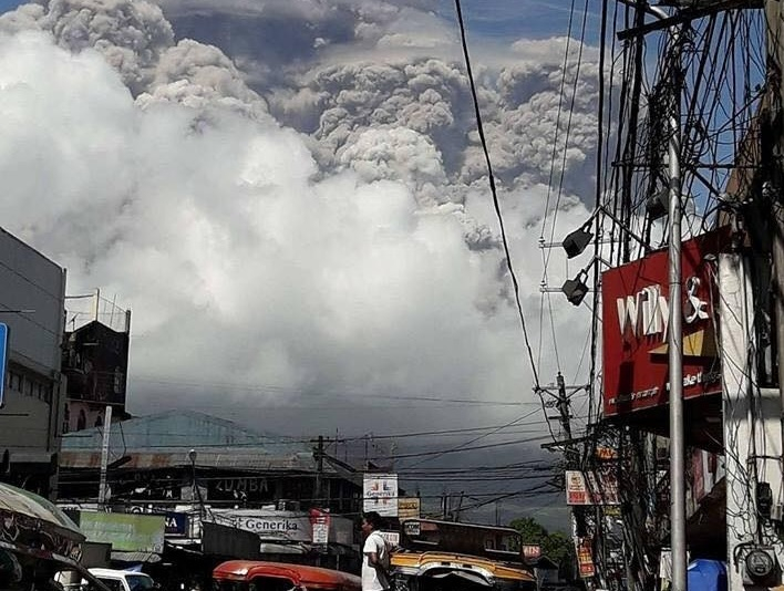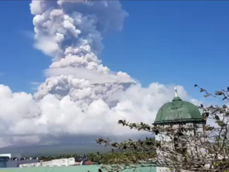
LEGAZPI CITY, Philippines: The Philippines’ most active volcano exploded thunderously Monday, January 22, sending a huge gray column of lava fragments, ash and steam into the sky.
Authorities warned a violent eruption may be imminent.
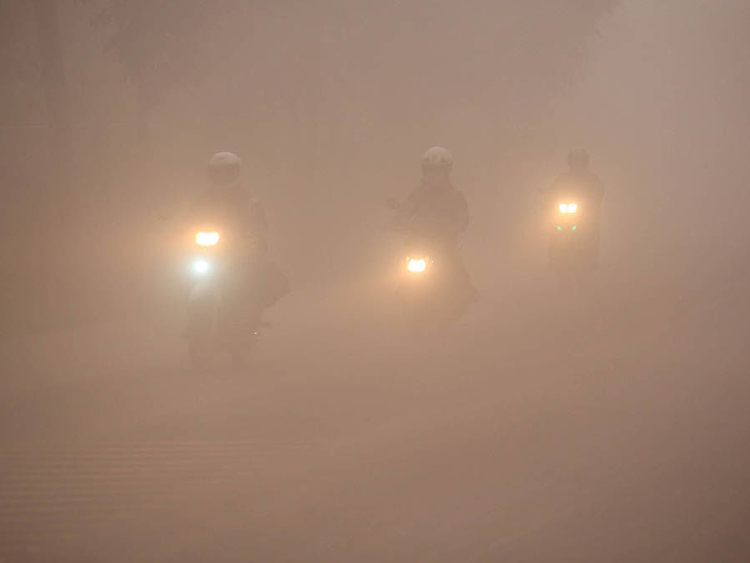
Locals reported that the several towns had been covered by volcanic ash. Several neighbouring towns had been affected too, while iin the city of Legazpi, with about 200,000 inhabitants, residents had been advised to wear masks.
About 30,000 residents had already fled the areas within the designated danger zone.
Updates here [all times local]:
6.44 pm
More lava flow creeps downslope from Mayon Volcano's crater with its direction following the existing volcanic gullies at the south western direction, says a Philippine volcanologist.
5.45 pm
Officials renewed calls for the evacuation of elderly and children, while people in the affected areas were urged to use face masks.
Meanwhile, the Philippine Institute of Volcanology and Seismology (Phivolcs) strongly advised the public against entering the danger zones around the slopes.
Residents in the areas designated as "danger zone" had been advised to move to evacuation centres outside the ashfall area.
5.21pm
The Philippine Red Cross announced that the danger area has expanded from 3.7miles (6km) to 5 miles (8km) from the 8,077 foot-tall volcano.
A hazard map released by the local government shows that besides Guinobatan, the towns of Malilipot, Sto Domingo, Part of Camalig and Bacacay are now inside the danger zone.
4.15pm
More than 34,000 locals have been forced to flee their homes as the eruption continues and a new map reveals the renewed threat the volcano can unleash upon villages and communities.
3.03pm
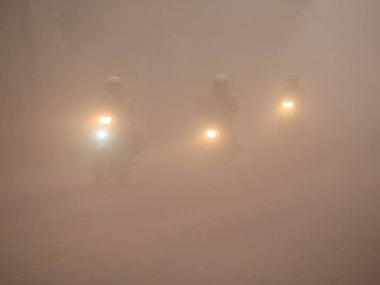
Local officials appear for help as TV footage showed thick ash raining down on Masarawag village, Guinobatan town in Albay. Up to 10km of volcanic ask and dust billowed out of the mouth of Mt Mayon on Monday.
The volcano sent superheated lava and molten rocks cascading down its slopes and shrouded nearby villages in darkness.
1.30pm
Ronald Pigtaen, Phivolcs Science Specialist 2, says all monitoring teams on the ground close to the volcano had been pulled out as a safety precaution.
1pm
Phivolcs raises alert level to 4 on a scale of 5, which means an explosive eruption is possible within hours or days.
A time-lapse video made by Time magazine and going around on social media shows the moment of Monday's thunderous explosion.
12.36pm
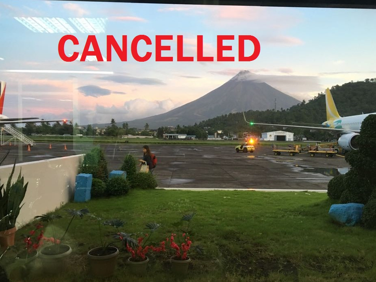
The Civil Aviation Authority of the Philippines (CAAP) shut down the Legazpi Airport in Albay and Pili Airport in Camarines Sur due to the threat of a Mayon Volcano eruption on Monday and cancelled at least 10 flights in and out of the two airports near the volcano.
CAAP's Notice to Airmen (notam) BO286/18 went into effect at 12:06 pm on Monday, January 22, and will be in place until 9 am on Tuesday, January 23.
The order may be renewed daily depending on the status of the Mayon Volcano. Cebu Pacific said the following Tuesday flights bound for Legazpi City and Naga City are canceled:
Manila-Legazpi: 5J 323, 5J 325, 5J 327
Legazpi-Manila: 5J 324, 5J 326, 5J 328
Manila-Naga: DG 6111, DG 6117
Naga-Manila: DG 6112, DG 6118
12.25pm
Classes in all levels in Albay province have been suspended due to ashfall.
12.12pm
The noontime explosion sends superheated lava, molten rocks and steam cascading down Mount Mayon’s slopes and shrouded nearby villages in darkness, said Renato Solidum of the Philippine Institute of Seismology and Volcanology and other officials.
Albay Governor Al Francis Bichara appeals for release of funds as evacuations continue amid the situation at the Mayon Volcano. More in this #ANCRecap. pic.twitter.com/LPA248LjkM
— ABS-CBN News Channel (@ANCALERTS) January 22, 2018
Classes at all levels in Albay province had been suspended due to ashfall while experts had advised residents to evacuate and wear dust mask as a safety precaution.
“If the eruption is vertical, it’s possible pyroclastic flows or pyroclastic density currents may cascade down in all directions,” Solidum told a news conference, warning villagers and tourists not to venture into the no-go zones and airplanes to stay safely away from the crater and ash-laden winds.
More than 27,000 villagers have fled since Mayon started acting up more than a week ago.
Location
Mayon is in coconut-growing Albay province, about 340 kilometers (210 miles) southeast of Manila.
With its near-perfect cone, it is popular with climbers and tourists but has erupted about 50 times in the last 500 years, sometimes violently.
In 2013, an ash eruption killed five climbers who had ventured near the summit despite warnings. Mayon’s first recorded eruption was in 1616 and the most destructive, in 1814, killed 1,200 people and buried the town of Cagsawa in volcanic mud.
The Philippines lies in the so-called “Ring of Fire,” a line of seismic faults surrounding the Pacific Ocean where earthquakes and volcanic activity are common.
In 1991, Mount Pinatubo in the northern Philippines exploded in one of the biggest volcanic eruptions of the 20th century, killing about 800 people.