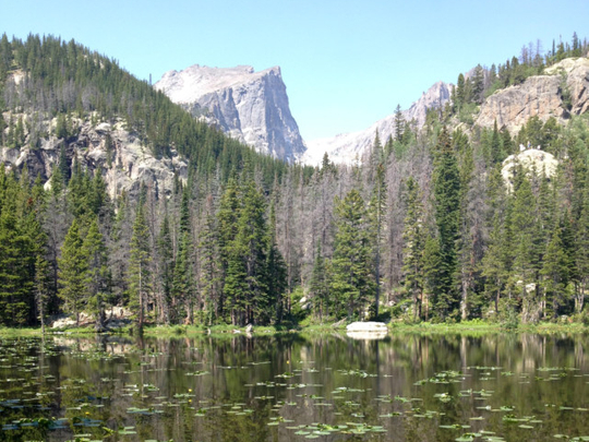
No adjectives can do Rocky Mountain National Park justice. The jagged snow-draped peaks, rocky tundra, green valleys, and roaring waterfalls render exclamation points inadequate.
The beauty is almost unearthly, and autumn is one of the best times to experience it. Aspen trees turn brilliant yellow; the bugle-like mating calls of elk echo in the mountains. And starting September 3, Rocky Mountain National Park launches a year of festivities to celebrate its centennial, including special hikes, wildlife seminars, art shows and a wild game culinary fest.
THE EASTERN SIDE
The Continental Divide runs through Rocky Mountain National Park, and the western side is greener and rainier, known as the “wetter, better side”, with more moose and bears — though a ranger told us only two dozen bears live in the park. The eastern side, while more crowded, is just a 90-minute drive from Denver’s airport, and my hiker pal and I decided to spend three days hiking here.
The gateway to the eastern side is the town of Estes Park, a tacky tourist mecca full of hotels, motels, souvenir shops and a few good restaurants. The park entrance is 8 kilometres up the mountain, but feels worlds away. The park has five campgrounds, with two open year-round, but we stayed in a low-key motel-lodge at the town’s edge, with an indoor pool and hot tub to soak tired feet after a day on the trail. It was a short drive from there to several trailheads, some best accessed by free park shuttle buses since parking lots often fill up.
PLANNING THE HIKES
Start at a park visitor centre to get maps and rangers’ advice on terrain, difficulty and distance. Some trails are even accessible to strollers and wheelchairs.
But remember this mantra in the high mountains: it’s not the distance, it’s the altitude. Many hikes climb above timber line, which is at roughly 11,000 feet in the park. Altitude sickness — which can include dizziness, headaches, fatigue and disorientation — can occur several thousand feet below that. So while a 17-kilometre hike might be a breeze at sea level, be prepared to cut your usual mileage and pace. Water is key: bring plenty and drink often to avoid dehydration in the arid mountain air.
Out of dozens to choose from, here are three memorable hikes, roughly 6-10 kilometres each and only moderately difficult at the toughest points — perfect for reasonably fit hikers.
BEAR LAKE CORRIDOR TRAILS
This system of trails south of Highway 36 is about 90 minutes from Estes Park. A park-and-ride shuttle lot is near the Bear Lake trailhead. We chose a roughly 10-kilometre route, steep and gravelly in spots, past serene Nymph Lake, covered in lily pads, and up past Lake Haiyaha — a must-see climb over huge boulders to glimpse a gorgeous blue-green alpine lake surrounded by jagged snow-capped peaks. We circled round past the turnoff to Mills Lake, with views of more peaks through forests of spruce, fir and quaking aspens, along the dramatic Alberta Falls waterfall, back to the trailhead.
UPPER UTE TRAIL
Even if you don’t make the entire 13-kilometre round-trip from on the Upper Ute Trail, from the Alpine Visitor Center to Milner Pass and back, you’ll still see awe-inspiring dramatic scenery, from barren tundra to alpine meadows and ponds, with stunning views of 14,255-foot Long’s Peak. While this is fairly easy terrain, beware of weather and high altitude. The trail starts at about 11,780 feet and you’ll be the tallest thing around on the barren first portion. Know the forecast — a must in the mountains but especially where you’re so exposed. The park’s first lightning deaths in over a decade occurred on or near this trail this summer. Darkening clouds and my hiking partner’s altitude sickness, including extreme fatigue, made us turn back before the pass.
DEER MOUNTAIN HIKE
The trail to the 10,000-foot summit, about 10 kilometres round-trip, wraps around the mountain, offering sumptuous views. Despite a steady climb, only the last portion near the top is noticeably steep. The lower altitude made it easier for my friend. A panorama of the park awaits at the top.
TRAIL RIDGE ROAD
The twisty drive along the section of Highway 34 known as Trail Ridge Road is also a must-do. It runs about 50 miles (80 kilometers) from near Estes Park to Grand Lake on the park’s west side, but even if you only make it to the Alpine Visitor’s Center, roughly half way, it feels like you’re on top of the world. It’s a seasonal road, open late May through mid-October.
___
If You Go...
ROCKY MOUNTAIN NATIONAL PARK: Campground reservations, trail maps, wildlife viewing tips, centennial festivities: www.nps.gov/romo/index.htm
Entrance fees: $20 per car, $10 per person for seven days.
ACCOMMODATIONS: Nearby hotels, motels, cabins, rental condos: www.visitestespark.com/lodging/
DINING: Near Estes Park, Mama Rose’s along the Big Thompson River (with outdoor seating when weather permits) offers delicious pasta, salads and garlic bread, www.mamarosesrestaurant.com
Rock Inn Mountain Tavern, on Highway 66 outside town, offers a cozy cabin-like interior, frequent live music, and varied menu (pan-seared trout, beefy burgers, hummus, roasted beets), www.rockinnestes.com
Splurge on a drink at the historic Stanley Hotel’s handsome tin-ceilinged bar. The hotel — which inspired Stephen King to write The Shining — serves food too: www.thestanleyhotel.com