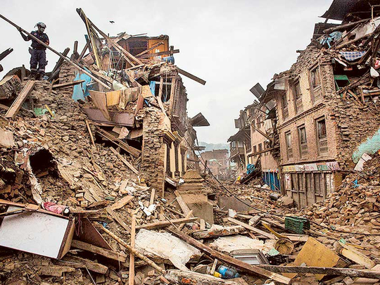
Washington: Earthquakes are one of nature’s most terrifying and destructive forces. Over the past decade, quakes in Haiti, China, India and Nepal have killed 400,000 people, while a 2004 earthquake-driven tsunami killed more than 250,000 people in 14 nations around the Indian Ocean. Last week, a quake struck Afghanistan and Pakistan, killing hundreds and destroying thousands of homes.
The United States has avoided the strongest temblors in recent years, but West Coast residents and earthquake scientists continue to worry about “the big one” there.
Now researchers say that with a combination of ground sensors and satellite-based instruments, they are getting closer to giving people a crucial minute or two of warning, though they acknowledge that predicting exactly where and when an earthquake will strike remains an elusive goal.
“When I started in this field 30 years ago, that was the goal,” Thomas Heaton, a professor of geology and geophysics at the California Institute of Technology, said about whether it’s possible to make such predictions. “But the answer today is pretty clearly, no. The more we looked at the problem, the more we understood that all the earthquakes aren’t the same.”
A short warning might not help if you are driving along an elevated freeway or if you’re on the top floor of a skyscraper. But researchers are working to connect these warnings to automated systems that would slow down trains; turn off gas lines; stop elevators and open their doors before they get stuck between floors; and turn all traffic lights red. The warning systems detect sound waves that occur just before a quake’s destructive shock, giving people and machines a little time to hunker down.
Los Angeles and the San Francisco Bay area are moving forward with a system called ShakeAlert because, sitting atop a series of faults, they are most at risk for a quake of around magnitude 8.0. (The last big California quake, in 1989, was magnitude 6.9.) In Seattle, which some scientists believe is overdue for a quake that could be greater than magnitude 9.0, researchers at the University of Washington began testing ShakeAlert this year, receiving data from sensors and then analysing it and generating alerts that are sent to system testers. In August 2014, California’s ShakeAlert system got a real-world test when a 6.0 earthquake rocked the Napa Valley in the middle of the night, injuring more than 100 people. An alert was sent to Bay Area Rapid Transit, which would have slowed trains had they been running at that time.
Some sensors have been deployed along the East Coast by the US Geological Survey and several university partners, but they are being used only to collect data about seismic activity.
Chile’s early-warning system helped give people time to prepare for the 8.4-magnitude temblor that struck on Sept. 16 and left eight people dead. A similar quake in 2010 killed more than 500 people; experts credit the warning system, along with infrastructure improvements, with the lower fatality count in the September event.
Mexico, China, Taiwan, Turkey and Israel are also developing earthquake detectors.
In the next five years, US officials hope to be able to send out text messages as much as two minutes before a quake — giving people a chance to duck and cover.
Such alerts, combined with more-sophisticated forecasting models and new ways of measuring temblors by using orbiting satellites, are examples of how technology is driving improvements in earthquake science, experts say.
Earthquakes occur either where tectonic plates are rubbing against or slipping under one another — the sites of such movement are called subduction zones — or along fault lines that lie underneath each plate that allow pressure from movements in the Earth’s crust to be released. These faults include the 1,3000kilometre-long San Andreas Fault in California and the previously unknown fault that caused a 5.8-magnitude quake to rumble through the Washington area in 2011, causing cracks in the Washington Monument and the National Cathedral towers.
They unleash huge amounts of energy. The 9.0 Tohoku quake in Japan — which released what scientists said were several centuries’ worth of tectonic plate pressure — jolted the sea floor 164 feet side to side and upward by 52 feet in 2011, creating a tsunami that killed at least 15,800 people and caused a meltdown at the Fukushima Daiichi nuclear power plant. The 7.8-magnitude Nepal earthquake in April 2015 moved Mount Everest an inch to the southwest.
They are also impossible to predict, according to Yehuda Bock, director of a centre at the Scripps Institution of Oceanography in La Jolla, California, that supports earthquake research.
“If you go into a lab and stress rocks, and create conditions that are in the real world, you won’t know when that rock is going to crack,” said Bock, who has been studying earthquakes since the late 1980s. “Eventually you will be able to get more and more information by looking at frictional qualities of the rocks. But to extrapolate to the real world is difficult.”
The San Andreas Fault, for example, runs 15 to 30 kilometres below the surface, Bock explained. “There you have different kinds of rocks, there could be water that lubricates the faults, there are very many variables.”
All those variables make predictions of weeks, days or even hours impossible. But that doesn’t mean that science can’t better understand how earthquakes work or how to read quakes’ signals.
Bock is a geodesist, someone who studies the shape of the Earth. In 1992, his system, which uses Global Positioning System satellites, was the first to monitor the deformation of the Earth’s crust before, during and after an earthquake, a magnitude-7.3 event near Landers, Calif. Two years later, a magnitude-6.7 quake struck in the San Fernando Valley near Los Angeles on a previously unknown fault, causing dozens of deaths and significant damage to infrastructure.
“Those two earthquakes spurred interest in what we are doing,” Bock said. “From that point on, we were able to steadily increase the number of stations.”
His system’s monitoring stations continuously collect GPS data that is transmitted in real time to the Scripps lab.
Specialised software uses this information to determine the precise position of the station in three dimensions with an accuracy of a fraction of an inch. By observing how the positions shift in seismically active regions, scientists can estimate the slow accumulation of strain in the crust due to tectonic forces. They can use these observations and other data to model the motion of the fault far below the surface. However, it is difficult to extrapolate these motions to the state of stress in the crust.
One way that Bock and others are trying to measure the likelihood of a future earthquake is by looking at the past. If they know that an area has a history of, say, magnitude-6.0 earthquakes every 30 years and there hasn’t been one for 60 years, that’s a good indication that one is overdue. Based on such information, scientists assign probabilities that a particular geologic fault will erupt within a certain number of years.
Yuri Fialko, a colleague of Bock’s at Scripps, has used this type of information to warn that the southern portion of the San Andreas Fault is overdue for a large earthquake.
Another indicator is how much the ground has moved on both sides of the fault. “If we can tell this fault should have moved by six inches and hasn’t,” Bock said, “then enough stress has built up that we are in a danger zone.”
“The stress can be released in one large earthquake or several small earthquakes,” Bock added. “But we don’t know exactly what magnitude it is going to be or when it is going to happen. We’re not at a point where we can predict earthquakes; we are at the point where you can issue probabilities of an earthquake happening over the next 50 years over a particular general location. We really can’t do much more than that.”
In 1988, the US Geological Survey said that Parkfield, California, was overdue for a magnitude-5.5 earthquake and expected one within the next five years. The agency wired the town with lots of sensors. But the quake didn’t happen until 2004, and despite the sensors it occurred without warning. Since then, USGS officials have shied away from making similar predictions.
“In academic circles, there is a fairly widespread feeling that [prediction] is not something that respectable people do,” said John Rundle, a distinguished professor of physics and geology at the University of California at Davis. “It stems from the fact that there have been many failures.”
While the five-year prediction about Parkfield didn’t come true, the USGS is taking the lead in the ShakeAlert warning system, which is relying on a combination of traditional seismic sensors and the type of GPS receivers that Bock and others have been using.
In 2013, the California legislature passed a bill requiring the establishment of such an alert system, but it didn’t approve any money. The federal government has approved only a small portion of the funds needed to build and operate the system. According to Doug Given, the USGS earthquake early-warning coordinator, about 600 of the planned 1,600 sensors have been installed, mostly paid for by cooperating companies and utilities.
For Given and others, the real challenge is not so much the science but the software engineering needed to get the alert out. The trick is picking up the initial signal of the quake, called the p-wave, or primary wave, and getting out that information before the s-wave, or shock wave, hits a particular spot, a time lag that can be as little as 10 seconds or as long as several minutes, depending on the spot’s distance from the quake’s epicentre.
“How do you get the notification out to millions of people in as little time as possible?” Given said from his office in Pasadena, Calif. “Most people assume that you can just send them a text message. No system can send 12 million text messages at one time.” (The population of the Los Angeles area is more than 18 million.)
Until such issues are worked out, earthquake alerts are currently going out only to first responders, utilities and companies that have earthquake-sensitive operations, Given said. The ShakeAlert system was used during an August 2014 earthquake that struck Napa Valley, just northeast of San Francisco. The Bay Area Rapid Transit system received the alert, however because the temblor hit at 3.20am trains weren’t running.
Sending mass alerts to “the general public is the very last step,” Given said. “It will require a significant amount of training and education. With the first Amber Alerts, many people were annoyed, and very upset. There’s a lot of social science and psychology to have alerts go right with the public.”