The ocean is eating away at the coast at a rate of 50 metres every two years according to data collected, so a battle to reclaim land to protect homes and provide beaches is going on.
Thanks to a hoard of information collected since 2000 from beaches along the Dubai coast, engineers from the Coastal Management Section at Dubai Municipality now know what to expect from waves and currents and which areas need the most protection.
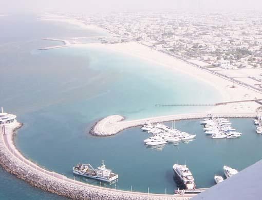
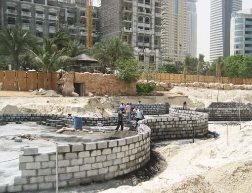
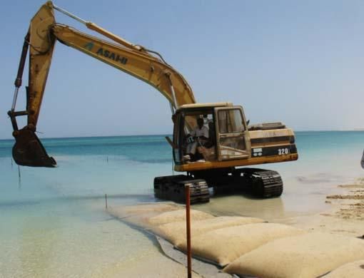
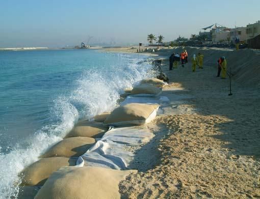
Without five-tonne bags of sand strategically positioned 100 metres from the shore to form protective groynes the recently nourished Umm Suqeim I beach would wash away, potentially taking houses along with it.
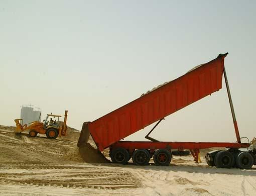
To combat coastal erosion caused by the impact of the sea, 500,000 cubic metres of sand has been poured along the shore to pad out the receding coastline in the past year, said Alya Abdulrahim Abdullah, head of the coastal management section at Dubai Municipality (DM).
The area under her authority stretches between the Sharjah and Abu Dhabi border, almost 70 kilometres, 10 nautical miles offshore and 1 kilometre inland. This area is defined as Dubai Coastal Zone.
Wave forecasting
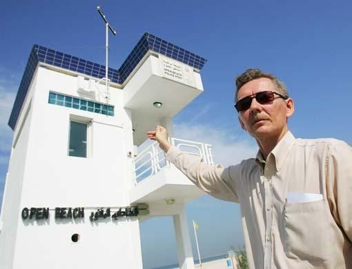
Real-time measurements of wind and wave speed, wave height and wave direction, air and water temperatures as well as water level and seabed contours, available on the newly restructured Coastal Monitoring website - www.dubaicoast.ae, help municipality engineers monitor what the sea is doing.
The site is also used by contractors as well as by beachgoers and kite surfers who rely on the 30-minute feeds for wind and wave conditions.
This data is captured by an Acoustic Doppler Current Profiler (ADCP) located at a depth of about 8 metres, about 200 metres offshore of the Jumeirah Open Beach breakwater.
By using the information collected engineers have been able to find the best positions for groynes and breakwaters to stop the sand from being washed away.
"Numerical wave forecasting and shoreline modelling are the basis for planning coastal protection schemes that should solve the problem of holding the sand for a few years at least. We are looking for short and medium-term solutions, let's say five years ahead, because in Dubai things change so fast," said Alya.
Coastal development guidelines for all developers are also in the pipeline and will be released early 2008, she added. As for the question of erosion, the problem is chronic and has always occurred along the Dubai coast, said Alya.
"The megaprojects have caused some erosion but we had severe erosion in many areas before these projects. Because of The World, the coastline is more protected but now the sand is just shifting in a different direction."
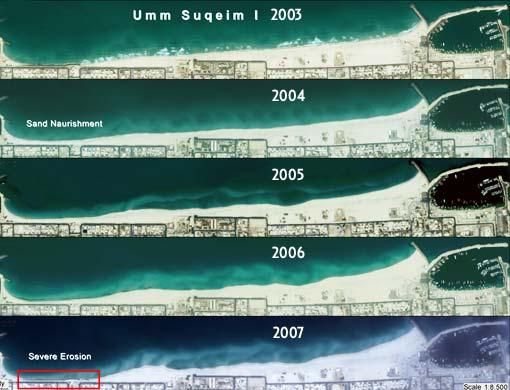
Satellite images help fight erosion and ensure sustainable shorelines
Coastlines are always changing and the shamal season is particularly fierce on Dubai's coastline, said Dr Claudia Giarrusso, coastal engineering specialist from the coastal management section at Dubai Municipality.
In some areas the beaches have moved several times already to the city's edge and back again, said Giarrusso.
Despite the 50m wide shoreline today, a few years ago some parts of Umm Sequim and Jumeirah did not even have beaches due to strong currents and waves striking the shore.
Coastal zone monitoring
The data collected from coastal zone monitoring has helped to pinpoint the areas where land reclamation is most needed.
In Umm Suqeim alone, 150,000 cubic metres of sand has been dumped and sand bags of between two and five tonnes will form groynes to protect and stabilise the beach, said Giarrusso.
"There are very strong tides here actually but extending the beach out to the sea does not affect the currents. Sand bags are a mitigation measure. Umm Suqeim 1 has always been subject to erosion. Nourishment and groynes will protect the public beaches as much as possible," she said.
Each time sand is dumped on the shoreline, efforts are made to reshape the beach profiles to maintain the natural slope of the seabed and make the beach as stable as possible.
Satellite images regularly acquired by the GIS Centre of Dubai Municipality along with field measurements are good indicators to monitor the speed of erosion, to identify critical areas subject to erosion and to eventually plan and design shoreline management measures that will have to take into account future offshore development.
"Since the construction of The World islands, the prevalent wave directions have changed. Erosion is faster because of diffraction effects. When there is an obstacle the waves do not go in a straight line but go around it instead, and the wave-induced current changes," she said.
The design of the groynes depends on what is going on offshore. "Long term here means five years and we adapt with whatever is going on. Our aim is to provide sustainable public beaches. We modify our modelling with the ongoing and future planned projects," she said.
Eye in the sky survey
Using advanced technology, a laser from a plane
is passed across the coastal zone, measuring around
1,000 sq km. The high resolution survey shows underwater
seabed features like sand dunes or sand bypassing breakwaters.
Nourishment
Construction sites within one kilometre inland from the shore automatically fall under the authority of the coastal management section of Dubai Municipality. Sand dug up at the construction sites is moved to the beaches as part of the nourishment scheme.
The Regulations and Procedures for Construction, Dredging, Excavation and Filling in the Dubai Coastal Zone as per Decree 22 of 2001 issued by His Highness Shaikh Mohammad Bin Rashid Al Maktoum, Vice-President and Prime Minister of the UAE and Ruler of Dubai, states that a No Objection Certificate from Dubai Municipality must be obtained before any construction, dredging and excavation activities are initiated in the coastal area.
The zone covers the entire extent of Dubai Creek as well as Al Mamzar Lagoon and any other excavated water connected to the Arabian Gulf.
Within this area, any excess volume of beach quality sand extracted from construction activities must be disposed off at specific locations as instructed by Dubai Municipality.
Cameras
Two cameras positioned on the 17th floor of the Burj Al Arab facing opposite directions help monitor the coastline.
Visuals of the waves lapping at the shore provide engineers with a better idea of the average shoreline. Years of footage has enabled the engineers get a clear idea how far the waves move forward.
Vladimir Shein, a senior surveyor and project manager working with consultant firm Dome International, said the images are sent automatically to www.dubaicoast.org for internet surfers to monitor the waves.
In future, nine more cameras will be positioned along the coastline from Dubai creek to Dubai Marina. At Jumeirah Open Beach, a radio receiver on the meteorological tower captures all the data sent by the Acoustic Doppler Current Profiler (ADCP).
Your comments
Perhaps, had some of the coral reef till remained, it would have protected the beach naturally.
kamilia
Dubai,UAE
Posted: December 07, 2007, 06:11